Posted by Chris Erikson on Oct 26, 2003, 15:35
 |
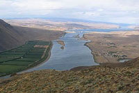
The Sentinel Gap slope site is on the extreme west end of Saddle mountain, overlooking the Columbia river. It is easily the most spectacular flying site on the Saddle mountain complex, quite a statement for an isolated mountain known for it’s incredible views and the expansive scenery at every site.
Copyright Chris Erikson 2003
Location: Central Washington, 20 Miles SW of Moses lake
 |
Driving Time: 2.5 hours from Seattle
Wind: SW to W to N
Weather sites:
Forecasts and current conditions
http://www.weatherunderground.com/US/WA/Hanford.html
Text, current conditions and record for last 24 hours:
http://weather.noaa.gov/weather/current/KHMS.html
Satellite Image of WA, updated every 15 minutes
http://www.wrh.noaa.gov/satellite/1km/Seattle/VIS1SEA.GIF
Access: Dirt road
Season: Year Round. Best March – May and Sept-Oct. Very hot in summer, very cold in winter.
Vertical Relief: 1400 feet
Skill level: Easy
Background:
Saddle Mountain is located in central Washington on the Columbia Plateau, about 9 miles S of Vantage.
The Sentinel Gap slope site is on the extreme west end of Saddle mountain, overlooking the Columbia river. It is easily the most spectacular flying site on the Saddle mountain complex, quite a statement for an isolated mountain known for it’s incredible views and the expansive scenery at every site.
The Columbia river sweeps directly beneath your feet through a nearly 180 degree arc which you can see at least 50 miles of river. In the distance to the north lies the Crescent Bar region just S of Wenatchee, at your feet the spectacle of the river cutting through Sentinel Gap, and then southward includes most of the Hanford Reach.
This superlative site offers faces for a high number of wind directions for anything other than wind with an eastern component. All faces have at least 1400′ of steep vertical relief working on your behalf to generate some exceedingly smooth big air.
See the Wahatis Peak report for a more info on a general description of Saddle Mtn.
Caution: There are rattlesnakes in this area, it’s smart to wear boots. Nearly every visit to this site results in a snake sighting. Be careful where you walk and especially around rock outcroppings.
 |
 |
Typical Weather:
Many windy days. Snow sporadically Oct-March, usually melts off after a few days. Temperatures climb into the 60’s in late March, and by May it can be 75-90+ degrees on the summit. Summer days are extremely hot here, and there is NO shade whatsoever, and no water, so be prepared.
Slope Terrain:
Entirely open, large, steep slopes. Dirt with flowers, cheatgrass, sagebrush, large boulders and outcroppings, medium sized rocks in soil.
 |
Flying:
With anything from SW to W to N wind, the lift is identical and very good, extremely vertical and smooth.
SW winds do not provide quite as wide a flying window at the other directions, but the payoff is it’s still huge, and all you do is walk along the hill if the wind directions change. In decent conditions, the top of the lift band is pretty much as high as you dare go.
On good days, keeping your plane down where you can see it is more of a concern than anything. Due to the large vertical component of the lift, penetration on windy days is not a huge problem, only really coming into play when you are trying to get back down.
 |
Landing zone: Moderately difficult.
The top is relatively flat, merely fly a bit downwind of the site and then try and drop down onto the summit area. This site earns the “moderate” rating for landings due to the boulders hidden in the sage that can and will take a bite of your plane, and the tricky task of finding the sweet spot between rotor and lift to hit the summit plateau, which is about 20 yards wide.
Walk of Shame:
Open slopes dotted with sage and boulders on N and W faces, but short cliffs and drops complicate the SW faces. Beware of rattlesnakes!
Camping:
Camping is permitted on BLM land, no facilities whatsoever, no cover either. Road “R1” on the E side of the road (just S of where “R” road passes under a second, upper set of power lines near the top of the mountain) leads to camping in a grassy valley if followed a mile or two, but is extremely sandy and can be problematic without 4WD.
At the summit road which runs westward out to the point, several small gravel pits along the roadside (about ½ mile west of the summit road junction) can provide a nice spot for small parties.
Please be extremely careful with fire, especially during summer and fall.
Slope Etiquette:
As you all know, land for sloping is now at a premium in many places and unless we act in ways that do justice to where we are allowed to fly, we can be, and are, banned from great sites.
All land surrounding the reserve, and the BLM land, is private. If you pass through any gate beyond the one gate you are permitted to pass through, you are on private land and again risk our access. Additional private land may be trespassed upon by accident as it is not all posted. The flying site is known to be BLM land, as well as the access route. The landowners patrol their land by motorcycle, have had problems with poachers, and being caught does not improve our relations. Do NOT camp, drive on, or fly on private land, please!
And lastly, please pick up every scrap of tape, foam, balsa, wrappers, or anything else you drop or find there. Lets keep this site free of hassles!
Road Conditions: Dirt with sandy stretches
Getting There:
Take I-90 to Vantage. On the east side of the Columbia, exit and head S on Hwy 26. In one mile, exit S to Hwy 26. Continue S on Hwy 26 through Sentinel Gap, then in a few miles turn E to the town of Mattawa.
Travel E from Mattawa for 1 mile, watching for “R” road on the left. Turn left on “R” and continue N. This will take you to the summit road in about 5 miles. All that is needed is to stay on the obvious best road.
At the canal crossing about one mile N from the highway, you will see a fence line directly ahead of you with a “no trespassing” sign. This applies to the road on the right side of the fence, which is a driveway. Take the road along the left side of the fence.
In a mile or so pass under the power lines and the road will turn W sharply and drop into a deep ravine then turn N again and begin climbing, reaching BLM land and a cattle gate with a sign detailing ORV use in about a mile.
Proceed N on “R” until on top of Saddle’s ridgeline, where there the road appears to turn right ( to the east) but is actually a “T” junction with a very sharp left. Turn left onto obvious best road, follow it a mile or so as it winds along the ridge top to another old gate which should be open. Go through gate and stay right, ignoring road to top of obvious bump about 500′ SW of gate. You are now about ½ mile from the site.
The road will immediately hit a stretch of sand with many dips and bumps while crossing a steep hillside. Any car should be OK, but be warned sand can be tricky for low passenger cars. After sandy stretch, the road will drop a few hundred feet to a broad saddle with a sharp peak directly ahead, this is the slope site. Drive as far up as you dare, park and walk the rest of the way.
 |
 |
 |