Slope Flying in and around Chamberlain, South Dakota
Why Chamberlain? Population 2347
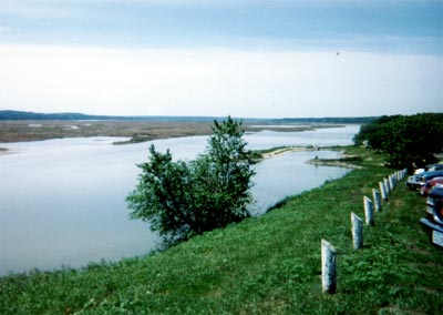
I have traveled through South Dakota many times over the past 30 years and have never stopped for any extended time to see anything other than Mt. Rushmore. But I kept noticing the spectacular view from the rest stop on I-90 at the Missouri river as I passed through. It looked liked great slope country. On this trip, made over the Memorial weekend just expressly to find this out, we found spectacular slopes in a very windy state.
|

Empty – friendly, windy; hot in summer; flat with abrupt hills; few or no trees. This is a huge state with only about 700,000 people. South Dakota is reputed to be the 4th windiest state in the Union. Very few people fly gliders in this area. My very good guide, and new slope buddy, Rob Hurd drove for 2 hours, from Sioux Falls, to try these slopes with me. We are probably the first to try – let’s hope others follow.
Excellent flying. I found that the big ships flew much better with the heavy thermal activity moving through with the fairly strong NW wind (15-25mph) during Saturday afternoon. Rob’s foamies flew fine at lower altitudes, but he had trouble getting height with them in the beginning. My LS-4 and the big “Vern Special” cruised up effortlessly to huge heights.
Plenty of turkey vultures were thermalling and sloping the sky that day.
Slopes also exist in and around Sioux Falls: contact person in the Sioux Falls area: Rob Hurd at 605-366-4076. Brookings area (north of Sioux Falls) also has slope sites. Ask Rob about this site. Get a Delorme “South Dakota Atlas & Gazetteer,” for the best map of this state.
|

Chamberlain area places to stay as well as information about the area: www.bbonline.com/sd/riverviewridge or http://www.chamberlainsd.org/
Places to stay: I stayed at a bed and breakfast place overlooking the Missouri River. This is run by Frank and Alta Cable and is called Riverview Ridge. It is 3 miles north of downtown Chamberlain on Hwy 50, which climbs steeply up to the ridge area. With west and NW winds you can fly a few hundred yards from the Cables’ residence. One could also fly from “Roam Free Park” about a mile away to the south of the Cables’ B&B. There are some possibilities of SW facing slopes in this immediate area.
The Missouri River snakes all over and has ridges 400 to 500 feet high on both sides of the river. The river is about half a mile to a mile wide.
|

Bijou Hills is a combination of Parker Mountain and Eagle Butte rolled into one range. There are absolutely no trees on the approaching flat land as well as on the hills themselves, and the terrain is dead flat leading to these hills. I drove for one hour in this area and only saw an oncoming motorcyclist and a farmer in a truck. This is one of the emptiest places in America.
I may be going back in July to try the Bijou Hills. We have only scratched the surface of the possibilities of slopes in South Dakota. Just don’t tell the hang glider crowd. We don’t need “dopes on ropes” to mess up these bluffs.
Twin Butte, which is over 2000 ft high, may be very worthy of future exploration as a slope site. It is about 5-10 miles west of the Bijou Hills area.
Final piece of advice: stay the hell off the Indian reservations.