The long wait is over. Things turned out a bit differently than we’d originally planned but our friends and fellow club members at AstroWings of Wisconsin helped us finally gain access to one of our local “Holy Grail” slope spots. Thanks to AstroWings, and especially Roger Zahn, as well as the folks at Waste Management for this opportunity.
Read more
Wisconsin
Slope soaring sites in Wisconsin.
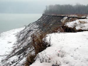
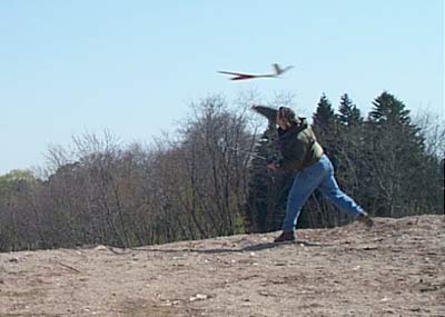
The Big M Platteville, WI 09-03-07
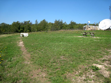
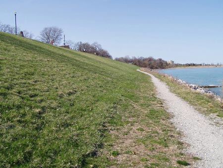
I stopped at The Big M in Platteville, WI today on the way home from the LEG Slopefest in Kansas for a little more slope flying. Can’t get enough! No one else there. Pretty decent conditions in the air. Not so great on the road that leads to the top. It was pretty sketchy. There is a large rill at the last turn before the top that requires a slow crossing and then you are mired in soft gravel. I made it through in the slopeflyer Chrysler T&C but realize that I drive this van where 95% of 4-wheelers wouldn’t so I’d suggest 4WD for now.
There is a new concrete bench really close to the LZ that makes landing a bit tricky so I flew my Predator Bee to test the lift and to try some different approaches for landing. I tried a new approach to the left of the stairs and it worked pretty well.
 |
That is the old bench on the right. |
After the Bee I got my newly tuned Skip Miller Slope (Mach Dart) out and ripped up the place. I’d already moved the CG WAY back from the original Mach Dart instructions and it was sitting about the middle of the rear bolt. After removing another 1/4 ounce in Kansas I think it is pretty near perfect. It did roll off on a tip when I got it really slow but this thing is supposed to be going fast so that shouldn’t be a problem.
The wind when i flew the Slope was 12MPH-15MPH and big thermals. There was pretty much lift everywhere and huge loops, screaming dives and multiple roll passes were a blast. I worked in some Cuban 8s, basic Split Ss and a fairly respectable snap roll. It is great having an excellent slope, good conditions and a sweet plane and not have to worry about anyone else in the air but, at the same time, flying with other guys is really what sloping is all about to me so after about an hour I packed up and finished my trip back to Milwaukee.
More bench pix.
 |
 |
Spring Valley Dam Pictures
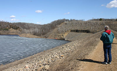
Emil sent these pictures in from a recent Spring Valley trip in NW Wisconsin.
 |
 |
 |
Big Bay Park, Whitefish Bay, WI
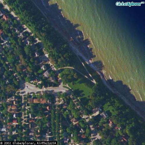
Big Bay Park, Whitefish Bay, WI
70 foot slope overlooking Lake michigan. Small, tricky landing area. 3 of us live within a mile of it!
Good bowl shaped slope on the shore of Lake Michigan a few miles north of Milwaukee. The slope is small, only about 70 feet but it provides good lift. The landing area is tricky and requires an up the face and plop it on the top approach. NNE to E winds, but if it gets East there are better slopes a bit south of here.
Read more
Spectacular Sunday at the Big M!
Mirko writes: This WAS one of the best days we ever had on any slope! It was no effort to climb out to 1000 ft at anytime of the day. Steady 25-30 mph winds, with over twenty different planes flying. Two different Compact Wizard 2X, four different Pixels, an Ellipse 3 CAM, Extreme, Psycho, Jedi, Hornisse, Fitness, and various trashy foamies. There were only three of us: Greg, Ken Nelson and myself. This was Ken’s first time ever to the Mound: he was just thrilled with the great conditions.
With all the dry, unplanted dark ground in front of the Mound, super strong thermals were constantly blowing through the lift zone, which allowed straight out, forward flight to huge altitudes all day. Very pleasant 70 F all day, with no clouds, until about 7:00 PM. This was the dream come true slope day. Best of all, no crashes or even, bad landings. The Wizards, Ellipse, Psycho, Jedi, and of course, the Pixels all were screaming like banshees.
Greg says: What a day! I have a new toy and it is not a plane. Have a look at the pix and you will see what it is!
All photos by Greg unless noted. (There is a second page of pix here)
 |
Sheridan Park Slope, St. Francis, WI
Posted by Greg Smith on Feb 24, 2003
 |
Sheridan Park, St. Francis, WI
About a mile north of Warnimont. Good with East winds and there is a spot at the South end that works all right from the Northeast. The top of the hill provides some good landing areas and this slope is a good place to test fly new planes.
Read more
Slope Flying at Warnimont Park, Cudahy, WI
Posted by Greg Smith on Feb 24, 2003
 |
Warnimont Park, Milwaukee, WI
This slope in southern Milwaukee County in Cudahy is 100 to 120 feet high. It is just behind the Cudahy High School. You can use the school football/athletic field across the street as a place to land. This slope is inside Warnimont Park just 4 or 5 blocks south of Layton Avenue.
The trap shooting site just south of here is also good. Both places work best in an Easterly wind.
Attention: There are a couple of alternate launch sites in this park, check them all before you launch!
Read more
The Slope at Bender Park – OakCreek, WI
Milwaukee Slope Flying Sites
 |
Bender Park, Milwaukee
Good 100+ foot bluff on the shore of Lake Michigan NNE to SE winds with slightly NE best. The best slope in the Milwaukee area is in Oak Creek at the end of Fitzsimmons Road or Oakwood Road. The walk up Oakwood is much shorter! Huge landing area, no trees, 100+ ft slopes, but of course one huge problem: Milwaukee County has closed it. There is a gate across the road. The county government closed this to re-build the bluff north of Fitzsimmons Road for a now defunct golf course. If you do not mind a bit of a hike you can park at the Marina at the end of Ryan Rd., head south and climb from the bottom.
Read more
Sloping at Concordia University, Mequon, WI
 |
Concordia University, Mequon, WI
Concordia University is located in Mequon, 15 miles north of Milwaukee. This is an excellent site for East and SE winds. Landing is tricky due to many small trees and bad rotor in higher winds. But there is high grass to plow into if you have trouble with a long approach. A couple of foot paths can make nice approach paths.
 |
Photo: Greg Smit |
Crystal Ridge – Franklin, WI
Crystal Ridge – Franklin, WI
Crystal Ridge is a landfill type ski hill in Southern Milwaukee County at 76th and Rawson Ave. Not a good idea when skiers are using it!
This place is also good for using the high-start. On light wind days, combine the slope with thermals.
Flying Reports
04/21/01 – 45 mph winds at Crystal Ridge.
04/13/01 – Tracy takes off work to fly!
Slope Flying at Theresa Marsh
Theresa Marsh Slope Flying Site – Mirko Bodul
Go up past West Bend on HWY 41.
About 7-8 miles past HWY 33, exit on HWY 28.
Go left (west) on HWY 28 for about 0.5 miles, take the first road left AFTER the HWY entrance and follow it. It is called Mohawk Road and snakes around for awhile (1 mile?) finally heads east with Theresa Marsh on the right dropping off gently.
I usually fly from the highest point to the left of the great big, brown sign, indicating that this is Theresa Marsh, wildlife refuge. Others preferred parking in the small lot a little lower and flying from there. Take your pick.
However, to the north of this road on top of this site is a cornfield, with electric or phone wires at the start of this field. If you climb up the embankment you can see how much that drops off to the north. If this is enough of a drop, I would launch to the south, from under the wires and work my way up with the plane and eventually walk north to an optimum spot for DS.
Let’s hope this does drop enough. With South and SSW winds some very good flying can be done here. I have attained huge altitudes here due to a thermal “kick” that comes in with the slope air. But be forewarned that this is not a “smooth” site: flying under 200 feet can be very bumpy.
Local Pilots
Mirko Bodul
Wisconsin Slope Flying Site near Black Earth
Wisconsin Slope Flying Site near Black Earth
Ceder Ridge Campground
is located 20 minutes drive from Madison’s West side on highway 78 midway between Black Earth WI and Prairie Du Sac Wi. 78 crosses US 14 a couple miles West of Black Earth, turn North on 78.
Below several pictures describing the approach from the south via Black Earth. Turn Right off Highway 78 to Dunlop Hollow Road approximately 5 miles up the road.
The images show the approch to the slope, road sign, the campground entry, the next shows the road up the back side of the slope and the final shot, with the cross is the slope site. If you look carefully at the approach shot the slope is visible in the background. Magnify and look for a white cross at the very top of the face of the hill…
This slope faces Southwest. Huge lift in 15+mph. South winds are blocked by a nearby hill. West winds are workable but increasingly challenging.due to obstructing trees and the lack of a west facing pilot position.
This is a foamy only site with very little margin for error on landing. The narrow landing area behind the pilot position at the cross is surrounded by high trees. In strong winds you fly over the top and drop down in the campsite behind. Hairy stuff, especially for the uninitiated.
Camping is available though primitive. The owner welcomes glider fliers and there is a camp fee box at the entrance shack where I drop a $5 bill as I pass. Rarely do I see any sign of life at the gate.
The area is infamous for its proliferation of folks of, shall we say “alternative” sexual orientation- Mazomanie nude beach overflow is my theory here…Overnighting at Cedar Hills is not high on my “adventure meter”, though the idea of awaking and immediately stepping out onto a slope is quite appealing.
The solid granite faces of the hill are rugged going when descending to claim a downed plane… beepers pay off here. I once hit the stone, nose in, “full tilt boogie” in combat with my original Zagi LE. The wing bounced several feet, rolled inverted, wabbled and continued to fly away… Amazing and memorable stuff. Pine trees around the crest provide cover from falling (plane) debris – kind of… In a head on collision my wing went belly to the wind and charged back at us and through the pilot position it impacted a tree at a dangerously high rate of speed and feet from my startled opponent–“crunch, splinter” .. ” I planned that”. The evergreen in question is to the right in the cross photo. This is the best and relatively safest place to stand. There is a nice swing out there on the corner but the best seat is right on the stone face, feet dangling over in the wind.
Plan dinner or cocktails at the new Rookies restaurant at the 14 and 78 intersection, then go buy rock climbing shoes at the famous and prolific Shoe Box shoe store in Black Earth a mile East. Both local landmarks are owned by the same fellow.
Cedar Hills fills a role for Madison slope- a- holics who for need of time or spousal leave- can’t make time to trek long distance to Platteville. Despite the challenges in landing this site can be huge fun in favorable wind conditions. Leave your balsa and composite ships at home, bring a foamie and someone to chase.
Local Pilots
Sloping in Verona Wisconsin
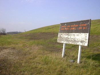
Site Report: Badger Prairie Park, Verona WI
submitted by Clayton Greaves
This slope is adjacent to a gas model field atop the landfill shown in the photos I have attached. Thusly, if you want to befriend fellow modelers at the field it is good practice to stop by- let anybody know where you will be flying and post your frequency to the control board.
This aeromodeling field is administered by the Dane County Parks. An annual user permit is $12 from the parks office. Occasional users could of course pass on this expense and post your AMA card, but don’t say you heard that from me…
South winds are best at this marginal lift site. South Southeast works too but any further to the east and the adjacent highway overpass obstructs the approaching winds. I have a good picture of this area and the obstacles involved. Southwest winds are problematic due to a grove of trees right in front of the slope but due south has the wind coming straight up the hill cleanly. Early this year there was a 36-minute flight with a Boomerang wing. My personal best is about 22 minutes with my Monarch HLG. I recommend you leave the lead sleds in the car when you arrive here. I often profit from thermals here on warm days, the asphalt road ahead of the hill probably contributes to this.
Directions:
From Madison take 151 South about 6 miles to the first Verona exit. At the first stoplight the slope is too your immediate right and hard to miss. There is a frontage road along the south face that leads to the currently active section of the landfill. If the gate is open you can park right at the base of this 50ish foot hill slope. If not, park along the West side or in the lot at the aeromodeling field and walk out to the edge, about 100 yards. I consider this site marginal when compared to the Big M in Platteville but since this is an eight minute drive from my office it makes for a refreshing lunch break stop.
Local Pilots
Clayton Greaves
|
|
|
Base of the slope looking West. |
|
|
|
View from the top. Road is due South, tree grove on the right creates turbulence in Southwest winds. |
|
|
|
View East from the top. Too much East and this highway overpass comes into play. |


Sloping in Stoughton Wisconsin
Wisconsin Slope Flying Sites
Sand Hill Middle School- Stoughton WI
submitted by Clayton Greaves
 |
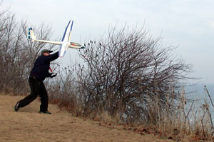
Here’s my slope infected son, age 3, launching my Boomerang at Sand Hill Middle School. What form!!!! The slope is approximately 50′ above the cornfield with about a 30 degree grade. This site, 4 blocks from my home only works with West winds.
Best success here is with lightly loaded hand launch gliders such as my 11 ounce Monarch or 10 ounce Zagi THL to my favorite 15 ounce Boomerang. Before we owned lighter ships we found this site a challenge with 20+ ounce combat Zagis- even in the strongest winds. the foreground is a huge 3/4 mile flat corn field, so the lift band, though narrow, is quite clean. Even in the best of conditions the lift here is only fair. Combat at this site is possible but would likely be marginal compared to other venues.
Directions: From Madison Take Hyway 51 ten miles south to county highway B. B is for bank- as you crest a hill and on the corner of B is.. you guessed it, a bank branch office out in the middle of hundreds of acres of corn fields. Turn left and you will immediately see the slope a mile up the road on the right. Turn at the first Right turn, Lincoln Street. The second drive enters the school grounds, around the south side of the building and the slope site on the edge of this playground.
Have fun and impress you friends side slipping you plane between the row of basketball hoops. Balsa ships “need not apply” Be sure to search for lift off the north end of the building ( visible in the photo background).. the stone surface adds thermals in warm conditions.
Note that visits to this site would need to be limited to evenings and weekends so as to not interfere with school activities, kids drooling on the windows, missing class etc. The janitors have been very friendly and once lent an assist when my plane found it’s way onto the roof.
 |
Local Pilots
Central Coast Area – Sheboygan, Manitowac and Kewaunee
Central Wisconsin Coast Slope Flying Sites
The Kewaunee slope
Kewaunee is about 30 miles north of Manitowoc. There is a very good site on the lake just after the Marina. As you pass the Marina on HWY 42, turn right on Hathaway Drive and follow it to the stop sign. Turn left to go up the hill. At the top of the crest is probably the best place to fly; there is a decent landing area between the road and the bluff. This road is a ridge road for a while. Direction is East to ESE. The interesting twist here is that there is a west facing bluff less than 100 yards from the lake bluff. This could offer Dynamic Soaring possibilities whenever there is a west wind – or even when there is an East wind.
Read more
Sloping in Port Washington, Wisconsin
|

Port Washington, WI
Located about 30 minutes north of Milwaukee, this slope is in North Lake Park. There is a spot just after the last parking lot that works well for Southeast winds. The landing area has a good selection of trees to make for a challenging approach but if you come in high and cross the road there is a good open field to set down in.
Local pilots
Unseasonable Warmth Brings Out Hibernating Slopers
|
January 26th, 2002 was a super day at the Big M. Unseasonable 50 degree temperatures and a strong SW wind brought out several slopers from Milwaukee and Madison, Wisconsin. |
|
|
|
Greg gets a DAW Mustang into the air. |
|
|
|
Pete launches his Cheetah |
|
|
|
Greg’s SH-50 just after launch. |
|
|
|
The Acacia II F3F prior to its inital flight. Looked the same after too! |
|
|
|
Away it goes. This is the first launch of Greg’s Acacia II F3F. Thanks to Andy Ellison in England for inital control throw settings this flight was great from the toss. A bit of a change to the elevator compensation with crow and it is pretty close. I will take out a smidgeon of nose weight to bring my CG back a bit and it should be spot on for me. |
|
|
|
THe DAW Mustang makes a pass. |
|
|
|
Tracy and Clayton model the latest in cool weather sloping gear. Tracy sports non-fog goggles and gloves while Clayton warms his hands in a |
|
|
|
Pete gets his Cheetah out into the lift again while Dan looks on. |


Racine Slope Flying Sites
Racine Slope Flying Sites
Racine, WI
In northern Racine County, Cliffside Park and a slope just south of that, Chapla Park are good for N to NE winds. Both overlook Lake Michigan.
Cliffside Park is almost inaccessible without a guide – me! (Mirko) I believe that I am the only one who has ever flown there. That was in 1998. It is only a 50 or 60 foot slope, but flying is good at both sites.
Ken Nelson added these sites for Racine:
FLYING SITE – CITY OF RACINE LAKEFRONT
There is a very flyable stretch of lakefront in Racine, Wisconsin south of the downtown area on Main Street between 14th and 16th Street. The slope is grass covered and very uniform in height. The slope is small at about 25-35 feet with large rocks at the base to prevent erosion of the slope.
Read more
Stellar Day at Concordia as the Winds hit 25 plus!
|
The wind was straight in at about 25 when I got to the slope. I put 16 ounces of ballast in the Extreme and spent 45 minutes tearing up the sky. This puppy covers ground really well and with the added ballast has super energy retention. In turns it doesn’t seem to loose speed and half pipes are a blast! Russ and Mirko showed up towards the end of my flight. Russ had intended to test fly his recently completed Pixel but with the 25 mph wind and no previous flight he thought it best to wait until conditions were a bit calmer to give it its maiden voyage. Mirko had his Sagitta out and Russ spent some time flying it too. |
Kou discovers several small slopes in Madison
Madison Wisconsin Slope Flying Sites
discovered by Kou Vang
Giddens Park, Lake Mendota, Madison WI
A small park facing N-NW onto Lake Mendota. Located on the Isthmus on N. Brearly St. behind a Church just off E. Gorham St. Parking space available at the top. Grassy slope is mowed all the way down to the lake. The slope is gentle and is about 50-80 feet above the lake and 30-50 yards from the shore. A small area facing NW is free of obstructions, but more N are 3-4 trees that are at the base of the slope and affect flow a little, getting above the turbulence created by them you’ll be in smooth air. This site is advisable in N-NW-W-NNE winds of 10mph or more. Recommend HLGs and foamies, Zagi’s work great. Landing is a little tricky in the small area and there are large trees and houses around the perimeter of the park. Lift is very good, but you must get above the turbulence created by the trees. Hour flights in 10+ mph N and NW can be had. Soaring is several hundred feet high depending on wind conditions and incoming thermals from the north shore. Bring lead for NW winds at 15+ mph.
Read more
N. Fork Bad Axe River, Dam site, Vernon County near La Crosse, WI
N. Fork Bad Axe River, Dam site, Vernon County near La Crosse, WI
reported by Kou Vang
A sloping treasure, if you can find this site and the wind directions are right you’ll be in DSing heaven. It is a dam site, holding back the Bad Axe River. County Y, goes right over the dam and there is parking on top of the dam. You have 100-200+ feet of almost vertical slope on both sides down to the lake on the north or a small stream on the south. I flew in south winds, which generated excellent, but turbulent lift. In south winds you are flying over a small stream and can land at the bottom on the flats. If flying in North winds you’ll be landing on the slope, on top of the dam or in the water. Wind directions Southish to Northish at 8+ mph recommended. In 10+ mph any size plane should fly and there is plenty of space for landing on top. Bring the Monsters out. The North face onto the Lake is less restricted and should give smoother lift, the South face is grassy at the bottom, but faces the tree line several yards back, so there is more turbulence. If DSing you’ll be doing it right across the road, but don’t worry few people travel this isolated route. The bad thing is the dam is located in a valley up in the hills, therefore wind direction can be somewhat restricted to directly S and N flying because of the flow within the valley.
This site is located in the Amish country of Vernon County, near La Crosse. It takes 25 minutes to get there from La Crosse. You’ll need a Gazetteer or you’ll get lost. From La Crosse, take 35 south till you get near Goose Island, then take a left onto County K and follow it for 8-10 winding miles until you reach 162 East (this will be an inclining exit of K, and leads into the town of Chaseburg). Right after Chaseburg take a right onto County KK and follow that for another 4-5 winding miles till you see Enterprise Road which you’ll take a right onto. Follow that for 1 mile till you reach County Y, where you will take a left and follow that for 2 miles till you reach the site.
Spring Valley Resevoir, Spring Valley, WI
Spring Valley Wisconsin Slope Flying Site
Directions to Spring Valley Slope (from Twin Cities)
Take 94 East through Hudson, WI to exit 19, which is HWY 63. Follow this for 7 miles to County Road 29 and turn left (East). Follow this into the town of Spring Valley. At County Road B turn left. Follow it through town to 2nd Avenue (stop sign here). Turn Left into 2nd Avenue (same as County B). Follow it West for one mile to 250th St.
Turn Right on 250th at the sign that says Eau Galle Recreation Area, turn right. When you get to the gate leading into the Corps of Engineers buildings, turn right and continue up a hill. Keep bearing right. You’ll come to a parking area with a covered look out balcony that overlooks the reservoir below. Park and walk down to the dam site.
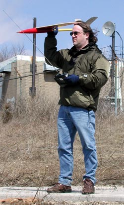
Great Conditions at Concordia for Greg and Mirko
Mirko gave me a call and said he was going to Concordia. When I arrived, Mirko was already tearing around with his Saggita at the North launch site.
I wanted to fly the Extreme because the conditions would have supported it and I haven’t flown it at a big hill for a while. However, I left the transmitter I use for that plane at home. Oops! Tracy knows what I am talking about. Fortunately, I had 3 other planes in the car that are all on a different transmitter.
I joined Mirko with my Mini Acacia and the lift was great. This hill supports several hundred feet of altitude when the conditions are right. Today they were. We flew for about 30 minutes during which time several people watched or asked questions. Mirko suggested to one guy that he should get the University to start a model airplane club.
Read more
Flying at the Big M 06/10/01
Platteville, WI – 06/10/01 Greg & Mirko
The forcasted 15-30 mph winds at the Big M in Platteville did not disapoint today. When we arrived at 10 AM the wind was out of the Southwest about 15 MPH.
I got out the Prodij and started flying while Mirko got one of his 2 Saggitas ready. I hadn’t flown this plane since the Midwest Slope Challange in mid-May and was anxious to get it in the air. A quick toss and the Prodij was climbing out well. The lift was already very good. I was practicing pylon racing starts and turns for awhile and then worked a few aerobatics.
Read more
Concordia Slope Flying 04/28/01
The wind gods let us down a bit on this day, but at least the directon was correct even if the velocity was not what we were looking for.


Greg and Tracy take a short drive to Crystal Ridge
04/21/01 – I flew the Vindicator first and had trouble finding the lift. I ended up landing it at the bottom of the hill in a convient field. I was not going to throw the Prodij off, but after some peer pressure from Tracy I gave it a throw. I worked a bit different area and was able to get about a 20 minute flight. I ended up landing the Prodij at the bottom of the hill too. The LZ at the top is small and rocks and buildings said don’t try it up here today. I would not say it was all that much fun. 45 mph may be too strong for this hill.
This was my first attempt at this hill. The wind direction seemed good, but the lift band was very narrow. I think a more Southerly or Westerly wind would work better because Southwest seems to get split on the corner of the hill. Tracy has flown in lighter winds and reports good lift
Tracy takes off a day of work to fly at Crystal Ridge
Crystal Ridge- Milwaukee, WI
Tracy’s Report – 04/13/01
I took Friday off to do nothing other than fly my planes. Bright and early Friday I went to Crystal Ridge to fly the Zagi off of the west face of the hill. Nice westerly wind, not too fast, but just right for my first try with this plane. The hawks were VERY interested in this new bird in their sky. I had one that flew about three feet off of the wing, mirroring every turn I made. He flew off after a while but returned with wings folded doing about 50mph! He screamed to a halt right along side the Zagi and again mirrored every movement. It was definitely the best soaring moment I’ve ever had!
Later on, I saw a group of four of them in a tight circle, thermalling over the trees below the hill. I flew over to them to get in their lift and none of them seemed to mind except a really bright red one. He descended to get a better look, then after deciding that I wasn’t much of a threat, let out a cry which was echoed by the other three. Too cool.
I also flew the Majestic with my new high-start to some amazing heights and one incredible 24 minute flight that could have gone much longer. I got nervous when a curiously low Sun Country jet flew almost right over the ski-hill. I came in for a landing immediately after that. I’m sure that the jet was over 6,000 feet and my plane never got above 2,000, but better safe than to be the cause of a disaster.
Later that day I flew the Xterminator at the local school. It was going great until I hit a light pole 50 feet off the ground with the wing. Depth perception was incredibly difficult against the clear blue sky. I thought I was well beyond the light pole. The plane skidded down along the pole toward the concrete base and shattered the fuse when it hit. Believe it or not, the plane still flew after the accident, even with the nose section splintered from the plane. After an hour repair job, I was back at the school with about 25 more flights (the next day my arm was so sore that I thought it would fall off!)
I went back to the ski hill on Saturday morning with the Zagi. The wind was blowing a lot more than the day before, so there was a LOT more lift. I had some incredible flights, very fast. Faster I think than I’ve ever flown before…which explains the crashes. It’s very easy to get disoriented with a flying wing. Did I mention that I love EPP? No damage done. I just tossed it out again for more abuse. I practiced bleeding off speed by coming up the face of the hill and plopping it down on the ridge on which I was standing. Got pretty good at it too. Landing a foam and glass ship will be tricky as the hill face is nothing but dirt and broken concrete. I think I’ll watch you do it before I try it with a plane of my own. The hill is excellent in northwest to southeast winds. You’ve got to try it.
Greg Flys at The Big M
Flying at The Big M
Platteville, WI – 04/01/01 Greg
I got the opportunity to fly at the Big M today. I was coming back from a wedding in Iowa and routed the return trip past this large mound in Southwest Wisconsin.
This was the second flight for the SH-50 and the conditions were perfect to test the plane more thoroughly than the first test flight, which was done in 6 or 7 mph winds. Today was about 15-18 mph. It was coming a bit more northerly than is ideal, but this place has very good lift and I had no problem putting the SH-50 through it’s paces. This plane flies very well! It accelerates quickly, rolls very fast and loops are tight. Pylon turns are quick and it is easy to work a small area of the slope. I flew it unballasted at about 17 oz. I can’t wait to ballast it up.
If you are going to be in the area and would like to fly here contact:
Greg Smith – ( I am a couple of hours away, but can make the trip with enough notice.)
Ellison Bay Slope, Door County, WI
On the Door County penninsula. This is a great place to take the wife or whole family for vacation and still have a place to fly.
There are two spots on either side of Hwy 41 that work well in a N or NW wind. Just before you enter the town of Ellison Bay you crest a hill, on the West side is a Hotel with the slope between the road and the Hotel, on the East is open land. The open land is platted for a subdivision though, so I am not sure how long that will be usable. The Hills are only 40 or so feet right where you launch but is about 150 feet above Lake Michigan and the wind seems to work better here that some other small slopes I have tried.
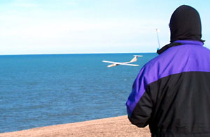
Wisconsin Slope Flying at Atwater Beach
Atwater Beach, Shorewood, WI – Experenced flyers only! People present!
Good for North East winds. Tricky or unconventional landing at the top (this involves coming at the slope, diving down, following the slope contour up to dump speed and plowing into a bush) but the beach is big and there is a path to walk down. This is a nice North Suburban Milwaukee site and very good lift in ENE winds. Not for beginners though!
Local pilots
Greg Smith
Russ
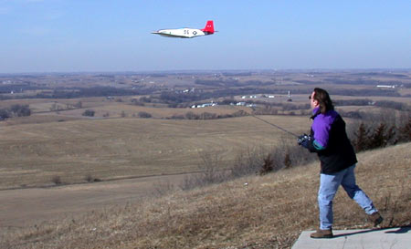
Sloping at the Big M in Platteville, WI
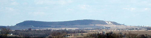
This view of the mound is from about 8 miles away. We fly over the Big M on the right side.
Wisconsin Slope Flying Sites – The Big M
The Big M is a large mound near Platteville, in western Wisconsin. It faces West but because of it’s shape it is usable for several directions from Northwest to South.

This view is from the top of the mound. The white patch on the left is part of the top of the Big M
From Madison take 18/151 towards Dodgeville. At Dodgeville continue on 151 towards Platteville. You will make a right turn at the end of town in Belmont (still 151) and will be about 7 miles from Platteville. You will see the mound off to your right. About 4-5 miles after Belmont is Mound Rd. (maybe West Mound Rd.) At the base of the mound take a right and the farm with the access road is on your left. You go between the farm house and the out buildings up the access road to the top where the antennas are.
Local pilots
- Greg Smith
- Clayton Greaves