slopeflyer.com

Tennesse Slope Soaring

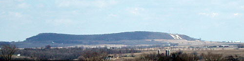
The site we use is 6 miles off Interstate I-75 between Lake City and Lafollette TN. In fact I-75 passes at the foot of the mountain. Called Cross Mountain by the USGS, it has three usable slopes. The smallest is the north slope, which is usable but the air is disturbed by a nearby point. The north slope pretty much requires a true north wind for good flying. The east slope is better and larger, overlooking a grand valley. From the east slope any wind close to east is good. The best and largest is the west slope, very big and bowl shaped. Any west wind, especially SW, works well. The uncluttered terrain of the west slope makes it the combat flyer’s choice! All the slopes have acres of good overgrowth-covered LZ’s. Below are the directions used by most everyone, although there is a 4WD-only route from Lake City. The exit is 30 miles north of Knoxville TN. Generally, going up you need to stay left, and down stay right.

The east slope, with it’s nearby tree line.

On Interstate I-75, use exit 134. From the south turn left at the end of the ramp then left again at Shoney’s restaurant; from the north go straight past Shoney’s. Just past Caryville Surplus Sales you will bear left and cross the RR, that will be Mountain Road. Approximately 1.7 miles from Shoney’s the pavement ends at Ivy Grove Church, go straight onto the gravel road. Start counting switchbacks! Keep going through 6 tight switchbacks; at 1.7 miles from the church you will see a cell phone tower on your right. Go 4/10 mile and one more switchback, then turn left onto a one-lane dirt logging road. This is the worst part, but not really bad! To help you, with a brief exception a power line runs all the way to the slopes, just follow and stay on the well-travelled road. Go 2.2 miles and you will see the north facing slope site, and the west and east sites along with the north slope access are just beyond there. Be sure to follow the same way back down that you did going up! There are no facilities of any kind on top of the mountain.

SUV’s can handle the roads easily, passenger cars may strike bottom if you are not very careful. Go slow and keep your lights on as many ATVs use the area for recreation and dust is a real problem for visibility! During the week logging trucks may be operating so be prepared to yield or back up. Also do not attempt the trip if your vehicle is mechanically unsound as a tow truck may not come to get you, or will charge you extra. This route is steep at intervals but will not overheat your vehicle if it’s in good condition.

Larry Blevins flies his mini-P40 inverted over the north slope.

The main contact for this site is Larry Blevins, who lives at the bottom of the 4WD route in Lake City, and is the owner of Magnum Models. Larry has been flying this site for years, and is an able guide. He can be reached in the evenings at 1-865-426-4826. Weekend flying is informal, with a promising weather report we contact each other and meet at Larry’s home or at the top of the mountain.

Here is the north slope as seen from the access road.
The bowl shaped west slope, as seen from the north end.

Ellison Bay Slope, Door County, WI

On the Door County penninsula. This is a great place to take the wife or whole family for vacation and still have a place to fly.

There are two spots on either side of Hwy 41 that work well in a N or NW wind. Just before you enter the town of Ellison Bay you crest a hill, on the West side is a Hotel with the slope between the road and the Hotel, on the East is open land. The open land is platted for a subdivision though, so I am not sure how long that will be usable. The Hills are only 40 or so feet right where you launch but is about 150 feet above Lake Michigan and the wind seems to work better here that some other small slopes I have tried.

SH-50 Compact Sloper

sh-50
SH-50 number 1

The SH-50 is a 50″ sloper designed to be light, fast and strong. Our slopes are mostly small and under 150 feet high. It is really nice to have a plane that is super manuverable and doesn’t need a whole lot of sky to have fun.

Airfoil: 7012 mod or 6063 mod
Span: 50.0
Area: 300 sq/in
Surface loading: 7oz/ft2
Weight: 16oz
Control: Aileron and Elevator
Radio: Hitec 555, CS-25s all around. 300mah pack.

4oz and 6oz lead ballast made to bolt in the fuse under the wing.

Designed and built by Greg Smith and Russ Whitford.


Kansas Slope Soaring at Wilson Lake

These are locations we have had the privilege to fly. Some may have access restrictions.
Check with local flyers for information.

Kansas Slope Flying Sites

Wilson Lake – This is the location of the Midwest Slope Challenge in May.

Race report from Wilson Lake 2001.

Wilson Lake is located at mile 153.9 on the Saline River, in Russell County, in north central Kansas. The damsite is about 45 miles west of Salina and 10 miles north of Wilson, Kansas. Interstate 70 is located approximately 7 miles south of the lake. Direct access to the lake is provided by Kansas 232 which crosses over the dam and connects Interstate 70 and Kansas 18. Access to the lake is also provided by Kansas 181 and numerous county roads on the north and south sides on the lake. The Dorrance Road, which connects with Interstate 70, and South Shore Drive are paved county roads that provide access to the parks on the south side of the lake. Other county roads are well maintained gravel roads.

There are several possible locations to fly depending on wind direction.

Local Pilots

Pat McCleave – Hi, my name is Pat McCleave and I have been sloping KS since the late 70’s. Of course my favorite site is Wilson Reservoir in north central Kansas but there are several others that are still quite Spectacular. Pat is working on a couple of other sites. Contact him for the latest info.

If anyone ever wants to do a Kansas Slope Safari let me know, I am sure we would have a great time.

Wisconsin Slope Flying at Atwater Beach

Atwater Beach, Shorewood, WIExperenced flyers only! People present!
Good for North East winds. Tricky or unconventional landing at the top (this involves coming at the slope, diving down, following the slope contour up to dump speed and plowing into a bush) but the beach is big and there is a path to walk down. This is a nice North Suburban Milwaukee site and very good lift in ENE winds. Not for beginners though!

Local pilots

Greg Smith
Russ

Sloping at the Big M in Platteville, WI

This view of the mound is from about 8 miles away. We fly over the Big M on the right side.

Wisconsin Slope Flying Sites – The Big M

The Big M is a large mound near Platteville, in western Wisconsin. It faces West but because of it’s shape it is usable for several directions from Northwest to South.

bigmtop

This view is from the top of the mound. The white patch on the left is part of the top of the Big M

From Madison take 18/151 towards Dodgeville. At Dodgeville continue on 151 towards Platteville. You will make a right turn at the end of town in Belmont (still 151) and will be about 7 miles from Platteville. You will see the mound off to your right. About 4-5 miles after Belmont is Mound Rd. (maybe West Mound Rd.) At the base of the mound take a right and the farm with the access road is on your left. You go between the farm house and the out buildings up the access road to the top where the antennas are.

Local pilots

  • Greg Smith
  • Clayton Greaves


Scroll To Top
Skip to toolbar