slopeflyer.com

Cleveland Area Ohio Slope Flying Sites


Reprinted with permission form Have Sailplane, Will Travel

Outstanding flying can be found on the southern shores of our Great Lake Erie, near the metropolis of Cleveland, Ohio, at the northern border of our country.


Much maligned and the brunt of many jokes in the mid 70’s, Cleveland has experienced a true renaissance period. With mass exodus of people to the suburbs in the 70’s, the city realized to keep the population, many changes needed to be made. Effort was put into rebuilding much of the infrastructure as well as revitalization of much of the abandoned or under utilized industrial sectors. Achievements such as renewal of the Flats entertainment district, birth of the Gateway Project with Gund Arena and Jacobs Field, homes of the Cavs and Indians pro sports teams, opening of the Rock and Roll Hall of Fame, The Great Lakes Science Center and the new Cleveland Browns Stadium as well as strong support for the many established cultural and civic organizations such as the Cleveland Orchestra and Playhouse Square illustrate our success in creating a truly “world class” city. Enough, you say?

Read more

Ohio Sloping – Columbus Area – Alum Creek Dam

Update from Tom Nagel!

The US Army Corps of Engineers has re-instituted its no slope flying rule at Alum Creek Dam.

Apparently the original no-fly rule was never rescinded, just not enforced, and the Westerville Model Aviation Club, whose field is at the base of the dam, had worked out a system to coordinate both sloping and flat field power flying.

Some non-flying officious intermeddler (that is an official legal term) raised the issue, and now the Westerville Club has voted to not allow any slope flying rather than risk losing their field.

Please remove my original posting from the slope flyer web site, and replace it with this information.  Don and I will keep you posted if things change again.

Cincinnati Area Sloping – Brookville Dam

Brookville Dam, IN

Brookville Dam in Indiana has been described by some as “the best inland slope in our part of the country”. It is located 2.5 hours from Louisville in Brookville, IN and about 1 hour from Cincinnati, OH. Brookville Lake is located in Franklin and Union Counties on the East Fork of the Whitewater River. The dam is about 1.5 miles above Brookville, Indiana, and 36 miles northwest of Cincinnati.

South winds work best here although there has been some noise made about DS potential in North winds. Several 4 hour, as well as at least one 8 hour, LSF flights have taken place at this site.

Read more

Texas slopes in Denton County

Thanks, David. Find other slope info at David’s site and an email link if you are going to be in the area.
http://msinow.com/rc/slope_soaring_in_north_texas.htm

Denton County Sites:
Lake Ray Roberts Dam:
Slope faces SSE, NNW. Aerial photo of the dam.

Directions: Go north on I-35 about 9 miles past Denton to Exit 478. Turn right on FM 455. Go several miles until you cross the dam, then make first right and follow it back to the mid point of the dam, the road ends there at a parking lot. There are restrooms, playground, and covered picnic tables. The park is a $3.00 self pay park. There is a drop box with instructions by the restrooms. To give you an idea how far this is, Exit 478 on I-35 is 67 miles north of north loop 820 and I-35W in Fort Worth. Not sure how far north of loop 635 and I-35E in Dallas.

Notes: S face is grass, N face is rock. I have been told the S face is a delight to fly — nice long grassy slope with plenty of lift, no obstructions. There is a road across the top of the dam, but it is not overly crowded and the slope is plenty tall to avoid any need to stray too close to the road.

Lewisville Lake Dam: I’ve heard that this is a flyable slope, but that flying is not allowed and they will run you off if you try.

Sloping in New York at Petersburg Pass

New York Slope Flying Sites

Thanks to Dave Garwood for this info that originally appeared in
an RCSD article in 1998.

LOCATION: Park in a gravel parking lot at the south side of State Route 2 in Petersburg, NY about 1/4 mile east of the NY/MA border. The flying site is 200 feet up a gravel trail to the south.

LAND MANAGEMENT: New York State Department of Environmental Conservation. Formerly a ski area, primary land use now is a hiking/backpacking staging area. Parasailors also use the site, though they launch from a partially cleared area across Route 2.

WIND CONDITIONS NEEDED: The west side is flyable in 5 MPH or more wind from the west or northwest. The big slope faces NNW, but is in the wind shadow of another peak to the north. The east side is flyable in SE 10 MPH or better.

RECOMMENDED PLANES: In suitable wind conditions., anything you have trimmed well and can fly confidently.


Petersburg Pass Slope Site

(NY/MA border)

If you are going through the Taconic Mountains that run along the Massachusetts / New York border you’ll find the Petersburg Pass Slope Site.

Pull into the parking lot at the top of the saddle back mountain on Route 2 between Petersburg NY and Williamstown MA, climb the gravel trail towards the south, and drink in two stunning vistas. To the west is Petersburg, and a bowl-shaped ridge that rises 900 feet above the valley floor. To the east is Williamstown and Mount Greylock, the tallest peak in the Berkshire mountains of western Massachusetts.

Both sides are flyable, and dynamic soaring is possible, if you’re really on top of your game.

This is Big Sky slope soaring, at least it seems like Big Sky to those of us who live where glaciers once covered the landscape. The bowl to the west creates a wide lift band when it’s working – you simply cannot fly out of lift and still see your plane.

“This is the best inland slope site I’ve ever flown,” said my 20-year old son, Lou, on our second trip there when we had 10-12 MPH wind. Lou’s been flying slope for about six years, and on that day flew a DAW 1-26, his trusty Sig Ninja, and a Slope Scale lead sled Mitsubishi Zero.

In 20 MPH, vertical development becomes impressive, supporting 250-foot loops. On his first visit there, Bob Powers quickly put away his NSP Sparrow and pulled out his ballasted-up carbon Renegade. “I don’t think we’ve ever flown this fast at Cape Cod,” Bob said after a few whistling fast passes.

The east side is flyable in SE wind, but so is Mount Greylock, only about 20 miles away, and in rare SE wind Greylock is the place to go.

Petersburg Pass is not a beginner flying site nor a spot for the faint of heart. It has the absolute trickiest launch point that I’ve seen in ten years of flying slope in eight states. You must launch through some intense turbulence and shoot through a break in a tree line until you get out into the lift, holding the nose down all the while to keep the speed up. It is an adrenaline-pumping moment, because there trees below.

Many trees.

The landing zone is surprisingly docile. It’s a grassy area about 100 by 125 feet containing only a few bushes and one surveyor’s stake on our last visit. It is amazingly free of turbulence and if you set up a reasonable landing approach you can grease it in on grass. If your downwind leg is too long, though, you’ll be in the tree line at the east end of the LZ.

CAUTION 1: Do not fly an untested or untrimmed plane at this site, at least not in wind higher than 5-8 MPH. Do not launch a plane with shaky batteries here.

CAUTION 2:  If  losing a plane will cause you permanent emotional damage, do not fly here. If a plane goes down over the forest below it will likely be impossible to recover.

CAUTION 3:  The Taconic Trail, a recreational hiking trail exits the woods smack into the center of the LZ. On landing, and for close-pass maneuvers you must post a spotter at that trail to watch for hikers. If we were to hit a hiker accidently, it could easily get us kicked out of the site.

These cautions are less urgent in lighter wind conditions. You can fly HLGs and long wing floaters in 3-5 MPH with less risk. Flying light and medium aileron slope soarers in 5-15 requires some attention to maintain safety. Flying slope screamers in 20 MPH or higher commands serious attention to safety issues.

All in all, Petersburg Pass is one memorable slope site. If your thumbs are up to it, consider putting it on your New York / New England travel itinerary.

These are locations we have had the privilege to fly. Some may have access restrictions.
Check with local flyers for information.


Oklahoma Slope Soaring Sites

Oklahoma Slope Flying Sites

One point of this page is to prove that there are flyable slopes in Oklahoma. There is a common misconception that Oklahoma is a flat as Texas. This is not true, unless you go really far west. The NE part of Oklahoma is hilly and tree covered. A couple of weeks ago I took a trip in search of the best, flyable slope in Oklahoma. One adavantage of slope flying in Oklahoma are the strong constant winds.  We, of course, owe this to Kansas and Texas 😉

Read more

Texas Sloping in Tarrant County

Thanks, David. Find other slope info at David’s site and an email link if you are going to be in the area.
http://msinow.com/rc/slope_soaring_in_north_texas.htm

Tarrant County Sites:
Benbrook Lake Dam:
Slope faces NNE and SSW Aerial photo of the dam

Directions: Mapsco 87Y. From I-20/Loop 820 in SW Fort Worth, go south on 377 into Benbrook. After about 1 mile you will turn left onto Lakeway, then after about 1/3 mile turn right onto Beach. Park beside the road before you get to the private park/beach gatehouse. Walk to the top of the dam. You can also continue on Lakeway and turn right on Lakeside to get to Longhorn Park at the east end of the dam.

Notes: N face is grass, S face is rock. If flying S face, fly at W end of dam where there is land at the bottom between the dam and the lake so you don’t have to land on the rocks if you can’t get back to the top of the slope. N face is a delight to fly — nice long grassy slope with plenty of lift, no obstructions or roads. Warning: this site is about 1 mile from the T-Birds R/C field, more or less depending on which end of the dam you are on. The field is on Mapsco 87W. Make sure you know where the field is and PLEASE take appropriate precautions for channel control. I suggest you drive over and post a note on their board or something similar to avoid shooting someone down or having your plane shot down, then remove the note when you are done.

Read more

Petersburg Pass Slope Site (NY/MA border)

These are locations we have had the privilege to fly. Some may have access restrictions.
Check with local flyers for information.

Massachusetts Slope Flying Sites

Petersburg Pass Slope Site (NY/MA border)

(OK, so technically it is in New York, but only .2 miles!)

LOCATION: Park in a gravel parking lot at the south side of State Route 2 in Petersburg, NY about 1/4 mile east of the NY/MA border. The flying site is 200 feet up a gravel trail to the south.

Sloping at Jeff Blatnick Park in Schenectady County

New York Slope Flying Sites
Thanks to Dave Garwood for this info.

Location: The Capital District of New York State.
Just east of General Electric Knolls Atomic Power Lab on River Road in Niskayuna.

From Exit 9 on I-87, the Adirondack Northway:

1. Westbound on State Route 146 for about 6 miles

2. LEFT at traffic light where SR-146 turns southbound

3. Cross the Mohawk River in Town of Rexford

4. LEFT at light at top of hill, eastbound on River Road

5. Continue through rotary in front of General Electric.

6. You’ll pass GE Knolls Atomic Power Lab

7. LEFT into Jeff Blatnick Park

8. Drive past two baseball diamonds

9. Go to end of parking lot, climb the hill.


Jeff Blatnick Park
Town of Niskayuna
Schenectady County, NY

This HLG and slope flying site is a capped landfill overlooking the Mohawk River, now used for walking, bike riding, roller blading. The hill is about 120 feet tall and about 400 feet long between tree lines at the ends of the field. It’s clear out front down to a partial tree line at the river bank. The hill face and the top is a large grassy meadow so landing is easy, as is recovering a downed plane.  Pleasant view, too.

The main problem is it needs EAST wind, an unusual direction, but it’s a public park so no problem with access. The Town has rules posted; one of the most interesting is “Animal traps not to be set within 200 feet of the centerline of the paved bike path.”  Pack out your trash, be courteous to the walkers and skaters, and we should be able to fly here for years.

This flying site achieved 15 minutes of fame in the soaring community when a Dave Garwood photo of Traveling Soaring Writerman GordySoar Stahl catching a Vaquero sailplane Ninja style appeared on the cover of OCT 1997 R/C Soaring Digest. http://www.b2streamlines.com/RCSD.html

Written by Dave Garwood, APR 2002.


Traveling Man GordySoar catches a Vaquero Ninja Style at Niskayuna site, about 90 feet over the Mohawk River. Thanks to RCSD Magazine for use of the photo.


Sloping in Lancaster County, PA


Pennsylvania Slope Flying Sites

Breezy View Park

Here in Pennsylvania we have a slope site which is popular with the locals as well as fliers from surronding states. On a good day we have folks from Maryland, New Jersey and other points west.

The site is in Lancaster county (amish country) near Columbia, PA. It is at Breezy View park which is part of the Lancaster County Park system. Our club – LASS (Lancaster Area Soaring Society) web site – http://lancareasoaring.org/ – worked with the parks system to establish the site for slope flying and includes a stone lane and parking at the site, a grass landing area and outdoor toilet – the last can be quite important. The site overlooks the Susquehanna River with the stacks of Three Mile Island in the distance. It is 220 ft. to the bottom of an 80 degree slope with a nice lift pocket at the junction of north and west faces. this is a “fly in your face” slope where combat is very popular with the advent of foamies. A nice west ridge line runs for 1/2 mile to the north making it good for doing turns with large ships. A 60″ ship is very comfortable on this slope. It works well with winds from west to north west at 15 mph and up – way up.

Read more

Slope Flying in South Dakota

South Dakota Slope Flying Sites

There are numerous bluffs along the Missouri, with 500 to 600 feet of elevation in South Dakota, most are on private ranches. If you are going to be in the area give Rob Hurd a call at 605-366-4076. You won’t find the spots in the following stories without him. South Dakota is a huge place and a lot of the residents like their space. Don’t go on any private land without the owners permission!

These are locations we have had the privilege to fly. Some may have access restrictions.

Check with local flyers for information.


Sloping in Idaho with Mike

These are locations we have had the privilege to fly. Some may have access restrictions.
Check with local flyers for information.

Idaho Slope Flying Sites

A special thanks to Mike for his descriptions on this site.

The land-owner of this site has developed the only suitable landing area which makes it suitable for foamie only, or planes which might tolerate rough landing. For the most part this wonderful site lost.

I fly slope almost exclusively as there is a very good one just 15 minutes from my home which is 20 miles west of Boise. I would be happy to direct you and others to the local slope. As I often fly alone there, the company would be appreciated.

“Freeze-Out Hill” is approximately 25 miles NW of Boise on the road to Emmett, ID.

Directions from Boise:
Take Hwy 44 (State Street) west from Boise, through Eagle and toward Star. Turn North on Hwy 16 (Emmett Hwy) at the intersection about 6 miles west of Eagle. Drive approximately 12 miles north (past Firebird Raceway on left) to a cross road with sign to “Pearl”. (If you start down the ravine into the Emmett Valley then you’ve gone to far.) Turn Left onto what is “Old Freeze Out Road”. About 100 yards up the road is a dirt trail which Y’s off to the right. Take this rough trail up the hill to the top (~ 0.3 mile). A regular car will make it easily with care. Continue on to the north and down to the right to a flat area facing NW (~0.2 mile). Park near the bigger sage brush on the shallow down slope to the right (this is the “landing” area so stay near the brush). The slope consists of a north bowl and a south bowl with a small central ridge. West to NW winds are best. Conditions worsen as winds get more northerly but may be flyable. (Note: conditions at the slope are not always the same as those in the Boise Valley.) Launch off the flat area over the central ridge. In a stronger wind (15-20+ mph) this is a great to awesome place to fly. In light winds conditions are difficult to predict and we often fly HLG and floaters. Please note this is private land and the area should be treated with respect. Take all your trash out and kindly pick up after others not as thoughtful.
Read more

Illinois Slope Sites

These are locations we have had the privilege to fly. Some may have access restrictions.
Check with local flyers for information.

Illinois Slope Flying Sites – Fults Hill

This is a public park in rural Illinois about 45 minutes from downtown St. Louis, MO. Head South on Rt 3 to Waterloo, right on 156, make hairpin turn at abandoned gas station onto Bluff Rd., past village of Fults, look for sign on right that says Fults Hill. Hike up the left-hand trail (not the wooden stairs). Et voila.

It’s a pretty spot. A few pix are at:

http://mvsaclub.com/mvsa/Flying_Reports/Entries/2009/1/31_Fults.html

The flying is best with southwest winds, which luckily are the prevailing winds at the site.

For best info, check with Paul Luebke or Ken Trudeau of the Mississippi Valley Soaring Association.

Indiana Slope Flying at Mt. Baldy

Mt Baldy, IN

Dave with a Bandit at Mt. Baldy


Mt. Baldy is a large dune at the Southern end of Lake Michigan. It’s part of the Indiana Dunes National Lakeshore, plus it doesn’t cost anything to park there. Wind direction for flying at Baldy, NW to NE with N best. Mostly winter winds, so bundle up!

Nice parking lot with bathrooms all winter, and a easy walk from the back through a woods to the top. About a 5 min. walk. We only fly there from Labor Day to Memoriol Day, too many people any other time.

Take 94 east, out of Gary Indiana, till you come to HWY49. Exit 26 by Chesterton.
Go north on 49 about 2 miles and turn right (east) on US-12.
Take US-12 about 7 miles and look for a Mt. Baldy sign on your left it’s at the first big curve in the road.
Read more

Iowa Slope Flying

These are locations we have had the privilege to fly. Some may have access restrictions. Check with local flyers for information.

Iowa Slope Flying Sites

The Levees – Clinton, IA – along the bank of the Mighty Missip is an earthen levee that works for smaller planes.

The Dam at Saylorville Lake – Nice Earthen dam near Des Moines. A slightly NE wind seems to work best.

There are some other sites that are available at certain times.
Contact the Eastern Iowa Soaring Society (EISS) for info if you are going to be in the area.

Hawaii – Pauwela slope soaring

Pauwela is the spot for hot-planes and hot-pilots. Small, fast and maneuverable are the watch words on this coastal slope. Timid flyers and newbies need not apply. Come back when you feel the need to take it to the limit.

In-Your-Face Sloping at Pauwela Lighthouse

Thanks to Duane Asami for permission to use this info.

Pauwela Lighthouse is for the very skilled aileron pilot only and is strictly the dominion of the small, high-speed, highly-maneuverable hotrods. Bring lots of lead, you’ll be needing to increase your wing loading to enjoy this site. Pauwela is flyable anytime the weather forecast calls for trade-winds, the stronger, the better. One M.I.S.O. member, flew a scratch-built U-2 here when his Kestral digital-wind-meter read fifty-four miles-per-hour.

You’ll want to fly something small here. Spans of 36″ to 48″ are great although the 60″ racers can also tear-up the sky. Don’t bother bringing a full-house two-meter or F3B ship here, you won’t want to throw it out. You’ll be flying in a “box” only about thirty-feet deep, thirty-feet high and a hundred feet wide. You’ll be flying at very high speeds with your plane less than 10′ from you as you move from right-to-left. Try something like a Mini-1 or a Blazer.

Pauwela Lighthouse is on the northern coastline of east-Maui. Follow Hana Highway (36) east out of Kahului towards the extreme east- end of the island. Look for a small community called Paia about seven-miles out of Kahului. After passing Paia, watch the milepost markers, you’ll want to go .8 mile past MP-11. You should see a pineapple field on the left (ocean side) of the highway and the Haiku Community Center on the right. Take the left onto the dirt road which runs along the edge of the pineapple field and follow it to the ocean. Beware, if it’s raining or the road is muddy, don’t go down there, you will get stuck; there are no phones and cellular phones won’t work out there. When you get to the bottom of the field, you’ll see a small lighthouse (actually, it looks like a small platform on a tall utility pole). Turn right and drive through the broken fence, across the grass to the cliff. If the wind is blowing in your face from the sea, you’ve found the spot.

Flying Pauwela is aerobic exercise at it’s best… You don’t get sore muscles, but your heart rate goes through the roof. Fly small “rockers” back-and-forth across the face of the cliff and don’t get too far out. The lift goes away and you’ll be in the ocean in a hurry. Also, don’t get too far to the left, it gets squirrelly there and planes have been known to disappear behind the lighthouse, never to be seen again. Landings here are actually not as traumatic as Waihe’e and much simpler once you get the hang of it. Fly from right to left and stay close in to the cliff. On the left, turn out and try to keep the nose a little high to keep from penetrating and building up speed. Let the wind push the plane backwards as you hover about five-to-ten feet off the ground. As it backs over the land, the lift will die and the plane will settle down like a helicopter.

Hawaii – Maluhia slope soaring site

Maluhia is a great place for big planes, for F3Bs, F3Js and expensive glass-slippers that need a lot of room to land. The lift is great, but far out so small planes get hard to see. The landing area is huge and almost anything will fly here.

These are locations we have had the privilege to fly. Some may have access restrictions.
Check with local flyers for information.

Maluhia, the Fly-What-You-Like Site

Thanks to Duane Asami for permission to use this info.

Maluhia, named for the Boy Scout Camp which leases the land, is north of Wailuku Town and about a mile north of Kapuna Point (Waihe’e). The lift is great when the trade winds blow and you can fly nearly any kind of aircraft you want. I have seen a hand-launched Gentle Lady and an Olympic II sharing the sky with a Modi (F3B), also hand-launched. It’s a great place to picnic while flying and couples often go there to just lay on a blanket and enjoy the view. The site is scenic, the lift is awesome and the landing area has been described as, “A two-acre foam pad”.
Read more

Slope Soaring in Arkansas

These are locations we have had the privilege to fly. Some may have access restrictions.
Check with local flyers for information.

Nick Trubov sent in this info about slope soaring sites within a half hour drive of Fort Smith, AR. There are several spots.

Lake Alma: which has a dam facing due North

There is a South/Southeast facing cut along I-540 just West of Ft. Smith that works great those two days a year when the wind blow from the SouthEAST!

The landfill has a slope that faces Northwest.

There is a slope on a private farm about thirty minutes north of my house that I would take people to, but not tell ’em about since it is private land.

Also in Fort Smith there is a levee on the north side of the Arkansas river which faces  Northeast and has lots of places to soar from. The levee is only twenty feet high but the wind comes in over really flat open farmland in most places. Take highway 59 east from I-540 just after crossing the Arkansas river if you are going North. (Hey, get off on this exit  just BEFORE you cross the river if you are going South, ok?) Start looking at the levee after driving about two or three miles to the East. Eventually you will cross another bridge that takes you back to  the other side of the Arkansas river and into Barling, AR.

Local Pilots

Nick Trubovntrubov@ipa.net
I can almost ALWAYS be convinced to go slope soaring. I used to live in Albuquerque, NM, where they have REAL slopes. It looks as if I am going to have to hire myself a D9 and buy some land and MAKE my OWN SW facing slope. That is the direction of the prevailing wind in the summer and so there are no slopes facing that particular direction.

Several Slope Soaring Spots in Connecticut

Dennis sent in this information on sloping in Connecticut

New Haven, CT
Thanks to Dennis Phalen

Greetings,

Winter is here, I transitioned from autumn to the coldest season on the slope in New Haven harbor. Lighthouse Point Park has a rocky shore just North of the boat launch ramp. The pathway is about 10 ft above sea level and a hill rises behind it. Sloping from this tree dotted path is good when the wind is out of the NW at 15-20. Today it was out of the NNW but still OK.

This is a really poor slope, but it’s only nine miles from my home. Of course there’s water only 20-30 ft away and the shore is as solid rock as the rest of the area here. Be prepared to get a plane out of a tree if you go there, wingtips brush the branches all the time and sometimes stay in contact until you free them. I have a longish pole made from downed saplings lying at the base of the tallest tree on the slope if you need it.

As its not a great slope I wouldn’t expect a DAW warbird to fly well there, but then no one around here has one of those either! I have flown heavy HLG and Wings there. Having the hill behind opens the lift area beyond what the lower slope provides, you can get a plane right overhead or even behind the path. Once up you’ll see that you can put the plane pretty far to the north end of the slope but you can still see it thru the trees!

We’ll probably have more of these NW winds. When you go there, pull into the first parking lot on the right. As you go towards the ramp you’ll see a path going around to the right, or you can just take the short walk through the woods/brush over the small hill. The slope next to the ramp will work with a W wind, go father for a NW. Pick a spot that lets you launch and fly, depending on the wind direction. You’ll be alone, turning a lot but sloping! There’s lots of brush to hit for landings but the path will work too. Have fun, call me before you go[email for number]! http://terraserver.homeadvisor.msn.com/image.aspS=11&T=1&X=1689&Y= 11421&Z=18&W=1

Colebrook, CT
There is also a group that flies at a dam in Colebrook, CT. A group of power fliers uses a N/S facing dam that is 200 ft on the dry side, 200 ft on the water side. One member has tried DS’ing there with some reward using a JW. http://terraserver.homeadvisor.msn.com/image.asp?S=14&T=1&X=206&Y= 1453&Z=18&W=1

Willimantic, CT
A couple of weeks ago I was at a dam next to Windham airport near Willimantic. A Zig zag of dams more than a mile long and maybe 30-45 ft high has multiple wind opportunities. The airport, with paved runway is RIGHT next door, there is no tower and not much activity but it could get dicey[I didn’t send you]. http://terraserver.homeadvisor.msn.com/image.asp?S=12&T=1&X=918&Y= 5781&Z=18&W=1

Dennis

Garland Hanson’s Arizona Slope Flying List

We have several VERY GOOD slopes in Arizona. Here are some of the most notable.

Green’s Peak
Located Near Springerville, the Sunrise Ski Resort, and the Hondah Casino. This is a 10,000ft peak with georgeous scenery. Elk, deer, and antelope are often in sight of the slope. It is grass covered and all models can be flown there. Most side of the peak can be flown. Access is unlimited and you can drive to the top and fly.

Green’s Peak will be the sight of the first Southwest Slopefest to be held this fall featuring one-design and unlimited slope racing (sound familiar?).

Brown Road Hill
Located in Mesa, AZ on the NW corner of the intersection of Ellsworth and Brown Road. This is a rugged site! i.e. foamies or sacraficial lambs ONLY! If the gate is open you may drive up otherwise its a 20 walk to the top over a winding road. Lots of vertical drop from the top and flyable from NW-W-SW-S-SE-E. One of the best sites in the Phoenix area.

P.S. The “no-trespassing” signs have been taken down.

Morman Lake Overlook
This site is actually the scenic overlook at Morman Lake located just southeast of Flagstaff. Drive up and fly right from the roadway. Georgous scenery and overlook of a mostly dry lake. Look for the 100+ elk herd that calls the middle of the lake home. Flyable in westerly wind ONLY. Good vertical face. Land down in the grass 200ft below if necessary. Nice site but not always flyable due to wind direction.

Sheba Crater
An actual volcanic cinder cone located east of Flagstaff. NO VEGETATION IN SIGHT!!! The top is accessible by 4WD ONLY! (DON’T EVEN TRY IT!!!) Landing is on very fine rock. Top is smooth and easy to land on (watch your car). Flyable on many directions. Owned by a hang-glider pilot. EXTREME sloping is to be had here.

Tucson
‘A’ Mountain (Sentinel Peak) is 1 mile west of downtown Tuscon.

Virginia Slope Flying at Mt. Trashmore

Virginia Beach, Virginia – Mt Trashmore

Mt Trashmore is a  recreation area located on the south side of I-264 in Virginia Beach. The hill is a wide V-shaped hill oriented with the bottom of the V pointed roughly Northeast. It is approximately 60 ‘ high with about a 45 degree slope to the North, a 20-30 degree slope  to the South and Southwest, and a 25 degree slope to the East.  The recreation management allows, within reason, small electric R/C aircraft and gliders (no gas).  Best days to fly are when the wind is from the South or Southwest as they come in over the “lake” run right into the top of the V and are the least disturbed by trees etc.  The flying area is also much larger to the S-SW as you can work most of the inside of the V and out toward the lake and don’t have to worry about the parking lot (or the highway) which are to the North of the hill. East winds are ok there but the slope of the hill to the East isn’t as steep.

Read more

South Carolina Slope at Pinopolis Dam


South Carolina Slope Flying Sites

Pinopolis Dam, SC

Pinopolis Dam is located about 4 miles north of Moncks Corner, SC. This dam site has a 60-70 foot face that faces southeast. The spot in the pictures is on the north side of the river next to the Jeffries Hydro plant.

Winds from south to east should work well here with southeast best. If the wind is out of the northwest, as it was on the day I found this site, the front side is usable although it is only 15 feet or so to the water. I used an SH-50 and was able to make a few passes before landing. A handlaunch plane would have been perfect, but my Xterminator’s battery was not charged

Directions

Take 52 north from Monks Corner about 4 miles to Powerhouse Rd. At the end of powerhouse Rd. you will see the dam. I checked with the guard at the Hydro plant gate and he said walking up is no problem, just do not drive.

These are locations we have had the privilege to fly. Some may have access restrictions.
Check with local flyers for information.

Slope Flying in and around Chamberlain, South Dakota

Slope Flying in and around Chamberlain, South Dakota

Why Chamberlain? Population 2347

I have traveled through South Dakota many times over the past 30 years and have never stopped for any extended time to see anything other than Mt. Rushmore. But I kept noticing the spectacular view from the rest stop on I-90 at the Missouri river as I passed through. It looked liked great slope country. On this trip, made over the Memorial weekend just expressly to find this out, we found spectacular slopes in a very windy state.
Read more

Sloping in Port Washington, Wisconsin

Mirko launching a big ASW-17 through a gap on the slope at Port Washington. Photo: Greg Smit

Port Washington, WI

Located about 30 minutes north of Milwaukee, this slope is in North Lake Park. There is a spot just after the last parking lot that works well for Southeast winds. The landing area has a good selection of trees to make for a challenging approach but if you come in high and cross the road there is a good open field to set down in.

Local pilots

Greg Smith

Mirko Bodul

Russ Whitford

Unseasonable Warmth Brings Out Hibernating Slopers


January 26th, 2002 was a super day at the Big M. Unseasonable 50 degree temperatures and a strong SW wind brought out several slopers from Milwaukee and Madison, Wisconsin.

Greg gets a DAW Mustang into the air.

Pete launches his Cheetah

Greg’s SH-50 just after launch.

The Acacia II F3F prior to its inital flight. Looked the same after too!

Away it goes. This is the first launch of Greg’s Acacia II F3F. Thanks to Andy Ellison in England for inital control throw settings this flight was great from the toss. A bit of a change to the elevator compensation with crow and it is pretty close. I will take out a smidgeon of nose weight to bring my CG back a bit and it should be spot on for me.

THe DAW Mustang makes a pass.

Tracy and Clayton model the latest in cool weather sloping gear. Tracy sports non-fog goggles and gloves while Clayton warms his hands in a
stunning red Katie Kaufmann Transmitter Mitt.

Pete gets his Cheetah out into the lift again while Dan looks on.

Racine Slope Flying Sites

Racine Slope Flying Sites

Racine, WI
In northern Racine County, Cliffside Park and a slope just south of that, Chapla Park are good for N to NE winds. Both overlook Lake Michigan.

Cliffside Park is almost inaccessible without a guide – me! (Mirko) I believe that I am the only one who has ever flown there. That was in 1998. It is only a 50 or 60 foot slope, but flying is good at both sites.

Ken Nelson added these sites for Racine:

FLYING SITE – CITY OF RACINE LAKEFRONT

There is a very flyable stretch of lakefront in Racine, Wisconsin south of the downtown area on Main Street between 14th and 16th Street.  The slope is grass covered and very uniform in height. The slope is small at about 25-35 feet with large rocks at the base to prevent erosion of the slope.
Read more

Stellar Day at Concordia as the Winds hit 25 plus!


The wind was straight in at about 25 when I got to the slope. I put 16 ounces of ballast in the Extreme and spent 45 minutes tearing up the sky. This puppy covers ground really well and with the added ballast has super energy retention. In turns it doesn’t seem to loose speed and half pipes are a blast!

Russ and Mirko showed up towards the end of my flight. Russ had intended to test fly his recently completed Pixel but with the 25 mph wind and no previous flight he thought it best to wait until conditions were a bit calmer to give it its maiden voyage.

Mirko had his Sagitta out and Russ spent some time flying it too.
Read more

South Dakota Slope Trip October 2001

In memory of Ed Harris 1933-2001.
Read a tribute to Ed by friend Jim Porter.

There are over 75 pictures on the site from this trip. Start looking at them here.

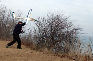
Well y’all, here is the beginning of the report on the 2001 South Dakota Slopin’ Safari, held over four days in the Chamberlain area of South Dakota. 25 pilots from around the Midwest made the trek. States represented included Wisconsin, Minnesota, Iowa, Michigan, Ohio and South Dakota.

Pilots started arriving early in the AM of Thursday, October 4th and were welcomed to the first sloping location by South Dakota resident and slope finder, Rob Hurd. Rob has done extensive research and travel to find the best locations for sloping in South Dakota and the next 4 days would prove that his search was not in vain.

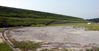
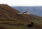
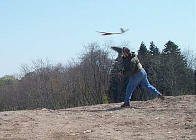
The location Rob chose for Thursday, located on a private ranch near Chamberlain, had a large area where pilots could drive to the top of the hill and fly just feet from their vehicles. The wind was light in the AM but flyable and with the thermals coming through there was no excuse not to get the flying under way.

Flyers continued to arrive throughout the day and there were 18 -20 who showed up on Thursday.

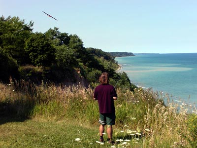
Many of the new arrivals chose to stay at the spot near the parking area. Several adventurous types followed Rob to a different hill that was about a 10 minute hike from the parking area. Shazam! It was a great spot for DSing! Several pilots took DSing 101 from Rob as most of the attendees had never done the DS thing before. We spent several hours finding our DS wings with Rob patiently looking on and offering advice.

Dinner at Al’s Oasis completed the evening and I went to sleep with the whoosh, whoosh sounds of DSing in my head.

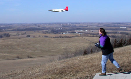
Friday looked to be a bit better for wind and it was blowing somewhat stronger with the late afternoon offering up 18-20 mph pretty consistently. Even with the decent wind pilots still had to contend with strong thermals and the ensuing sink throughout the day.

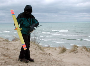
Give a soaring junkie a new toy and see if he can resist! Several more pilots made the trip to the DS location, no doubt encouraged by those who had done it on Thursday. I spent the whole day there! Who says junkies are not sociable, you just have to come to my crib!

The highlight of Friday’s flying, for me anyway, was a tossup between DSing my Prodij and Extreme and watching Dave Hauch DS his 2 meter Duck! Here was the sound: Quack, Quack, Smack! Too bad it had to end that way Dave!

Prime Rib at Charley’s did the trick for many a hungry tummy on Friday evening.

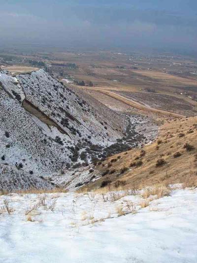
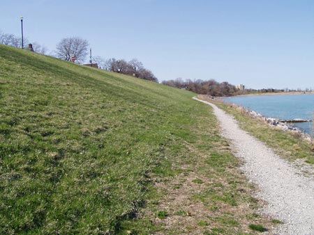
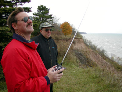
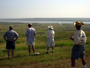
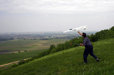
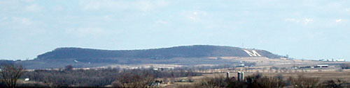
Saturday and Sunday were spent front siding at another private ranch about 5 miles from the first site. The slope here was spectacular! The ridge is about 250 feet above the land immediately below and then it slopes down another 300 feet or so to the Missouri which is less than 3/4 mile away. The bowl shape of the site would make working it from different wind directions possible although it was pretty consistent on the two days we were there.

Saturday the wind was a bit light, but most people brought planes for light air. As the day progressed, and the thermals started to add to the available lift, many different birds made it into the air.

Rob, Larry, Walt and several other guys had some combat going later in the day while Dave and I, as well as a couple of other “crunchie” flyers, used a different spot on the slope. There was room for all.

A big group dinner and plenty of hangar talk took place at Al’s Oasis on Saturday evening.

Sunday started out with better winds and as more guys packed up to leave, it kept building. Dave and I got in some good flights with our Vindicators. I had the Extreme and Prodij out as well. Mirko had a nice flight with his 4 meter LS-4 and avoided what could have been a disaterous landing behind the hill when his plane hunted out the tallest grass around to settle in. Walt and Emil really got their Zippers dialed in.

One of the highlights of Sundays flying was playing “last guy to pull up wins” with Rob and Larry. Basically we all start at about the same altitude, dive for the valley floor and wait until the other two chicken out. I think we all were about equally daring, although I am sure Rob won one of the rounds because I swear he breezed a tree at the bottom.

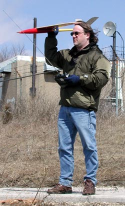
A partial list of planes flown during the 4 days: Zagis galore, Boomerangs, Brisk II, Image, 2 Vindicators, Extreme, Prodij, 4 meter LS-4, Hillbilly, several Zippers, several Fun-1s, several JWs, 2 meter Duck, Wide Glide, Eli 2, Vern Hunt F3B, a couple of Vern flying wings, several foamy warbirds, Encore, Scar, Windfree, SH-50, Mini-Acacia, 2 Sagittas, several 60 inch racers from MRCSS, 2 meter DAW 1-26 and many more!

Kou discovers several small slopes in Madison

Madison Wisconsin Slope Flying Sites
discovered by Kou Vang

Giddens Park, Lake Mendota, Madison WI
A small park facing N-NW onto Lake Mendota. Located on the Isthmus on N. Brearly St. behind a Church just off E. Gorham St. Parking space available at the top. Grassy slope is mowed all the way down to the lake. The slope is gentle and is about 50-80 feet above the lake and 30-50 yards from the shore. A small area facing NW is free of obstructions, but more N are 3-4 trees that are at the base of the slope and affect flow a little, getting above the turbulence created by them you’ll be in smooth air. This site is advisable in N-NW-W-NNE winds of 10mph or more. Recommend HLGs and foamies, Zagi’s work great. Landing is a little tricky in the small area and there are large trees and houses around the perimeter of the park. Lift is very good, but you must get above the turbulence created by the trees. Hour flights in 10+ mph N and NW can be had. Soaring is several hundred feet high depending on wind conditions and incoming thermals from the north shore. Bring lead for NW winds at 15+ mph.
Read more

Spring Valley Resevoir, Spring Valley, WI

Spring Valley Wisconsin Slope Flying Site

Directions to Spring Valley Slope (from Twin Cities)
Take 94 East through Hudson, WI to exit 19, which is HWY 63. Follow this for 7 miles to County Road 29 and turn left (East). Follow this into the town of Spring Valley. At County Road B turn left. Follow it through town to 2nd Avenue (stop sign here). Turn Left into 2nd Avenue (same as County B). Follow it West for one mile to 250th St.

Turn Right on 250th at the sign that says Eau Galle Recreation Area, turn right. When you get to the gate leading into the Corps of Engineers buildings, turn right and continue up a hill. Keep bearing right. You’ll come to a parking area with a covered look out balcony that overlooks the reservoir below. Park and walk down to the dam site.

N. Fork Bad Axe River, Dam site, Vernon County near La Crosse, WI

N. Fork Bad Axe River, Dam site, Vernon County near La Crosse, WI
reported by Kou Vang

A sloping treasure, if you can find this site and the wind directions are right you’ll be in DSing heaven. It is a dam site, holding back the Bad Axe River. County Y, goes right over the dam and there is parking on top of the dam. You have 100-200+ feet of almost vertical slope on both sides down to the lake on the north or a small stream on the south. I flew in south winds, which generated excellent, but turbulent lift. In south winds you are flying over a small stream and can land at the bottom on the flats. If flying in North winds you’ll be landing on the slope, on top of the dam or in the water. Wind directions Southish to Northish at 8+ mph recommended. In 10+ mph any size plane should fly and there is plenty of space for landing on top. Bring the Monsters out. The North face onto the Lake is less restricted and should give smoother lift, the South face is grassy at the bottom, but faces the tree line several yards back, so there is more turbulence. If DSing you’ll be doing it right across the road, but don’t worry few people travel this isolated route. The bad thing is the dam is located in a valley up in the hills, therefore wind direction can be somewhat restricted to directly S and N flying because of the flow within the valley.

This site is located in the Amish country of Vernon County, near La Crosse. It takes 25 minutes to get there from La Crosse. You’ll need a Gazetteer or you’ll get lost. From La Crosse, take 35 south till you get near Goose Island, then take a left onto County K and follow it for 8-10 winding miles until you reach 162 East (this will be an inclining exit of K, and leads into the town of Chaseburg). Right after Chaseburg take a right onto County KK and follow that for another 4-5 winding miles till you see Enterprise Road which you’ll take a right onto. Follow that for 1 mile till you reach County Y, where you will take a left and follow that for 2 miles till you reach the site.

Great Conditions at Concordia for Greg and Mirko

Mirko gave me a call and said he was going to Concordia. When I arrived, Mirko was already tearing around with his Saggita at the North launch site.

I wanted to fly the Extreme because the conditions would have supported it and I haven’t flown it at a big hill for a while. However, I left the transmitter I use for that plane at home. Oops! Tracy knows what I am talking about. Fortunately, I had 3 other planes in the car that are all on a different transmitter.

I joined Mirko with my Mini Acacia and the lift was great. This hill supports several hundred feet of altitude when the conditions are right. Today they were. We flew for about 30 minutes during which time several people watched or asked questions. Mirko suggested to one guy that he should get the University to start a model airplane club.
Read more

South Dakota Slopin’ Safari – July 2001

South Dakota Slopin’ Safari – July 2001
by Ed Berris

Walt Huemmer, Dave Engleson, Dave Fisher, Lee Berris (my son) and I drove to Central South Dakota for the 2001 slope expedition. We met Mirko Bodul and South Dakota slope guide and all around good guy, Rob Hurd waiting for us on the side of the road off interstate 90.  Mirko had left Milwaukee on the 18th so he already had plenty of flying time completed by the time we arrived early Friday afternoon.

Walt, Ed, Dave E. and Dave F. at the ranch in South Dakoa


We wasted no time heading to what turned out to be the most fantastic slope site I’ve visited and that includes Torrey Pines in San Diego. The hill was over 500 feet tall and the bowl shaped area we flew in extended all the way down to the river/lake below. It was not only beautiful but also a fantastic place to fly from.

The farmer that owned the land came up each day we were there to watch us fly and to visit. He and his son couldn’t have been friendlier and we also enjoyed their company. On Saturday night he (the land owner) suggested that we visit one of the restaurants that he was familiar with. He told us to be sure to tell the hostess that we were flying on his land and to treat us right.  Actually, we didn’t have to do that because while we were waiting to be seated for dinner, he called the restaurant himself to tell the owner that we were guests of his and to make sure they took good care of us.

Read more

Flying at the Big M 06/10/01

Platteville, WI – 06/10/01 Greg & Mirko

The forcasted 15-30 mph winds at the Big M in Platteville did not disapoint today. When we arrived at 10 AM the wind was out of the Southwest about 15 MPH.

I got out the Prodij and started flying while Mirko got one of his 2 Saggitas ready. I hadn’t flown this plane since the Midwest Slope Challange in mid-May and was anxious to get it in the air. A quick toss and the Prodij was climbing out well. The lift was already very good. I was practicing pylon racing starts and turns for awhile and then worked a few aerobatics.
Read more

Indiana Sloping at Brookville Dam

Brookville Dam, IN

Brookville Dam in Indiana has been described by some as “the best inland slope in our part of the country”. It is located 2.5 hours from Louisville in Brookville, IN and about 1 hour from Cincinnati, OH. Brookville Lake is located in Franklin and Union Counties on the East Fork of the Whitewater River. The dam is about 1.5 miles above Brookville, Indiana, and 36 miles northwest of Cincinnati.

South winds work best here although there has been some noise made about DS potential in North winds. Several 4 hour, as well as at least one 8 hour, LSF flights have taken place at this site.
Read more

Slope Flying at Coronado Heights 5/20/01

On my home from the Midwest Slope Challenge I stopped at Coronado Hights, near Salina, Kansas with Pat and Randy McCleave.

A view from the top. The lift was good, with 15 mph or better winds and thermals coming through every few minutes.

Uh, guys the rain will be here in about 2 minutes. OK just another minute then.

Pat’s warbird makes a pass.

Mike’s Foam-1 banking hard.

Some of the hazards of this site.

The castle in the distance. The LZ on this day is between the guys and the castle.

Greg and Tracy take a short drive to Crystal Ridge

04/21/01 – I flew the Vindicator first and had trouble finding the lift. I ended up landing it at the bottom of the hill in a convient field. I was not going to throw the Prodij off, but after some peer pressure from Tracy I gave it a throw. I worked a bit different area and was able to get about a 20 minute flight. I ended up landing the Prodij at the bottom of the hill too. The LZ at the top is small and rocks and buildings said don’t try it up here today. I would not say it was all that much fun. 45 mph may be too strong for this hill.

This was my first attempt at this hill. The wind direction seemed good, but the lift band was very narrow. I think a more Southerly or Westerly wind would work better because Southwest seems to get split on the corner of the hill. Tracy has flown in lighter winds and reports good lift

Tracy takes off a day of work to fly at Crystal Ridge

Crystal Ridge- Milwaukee, WI

Tracy’s Report – 04/13/01

I took Friday off to do nothing other than fly my planes. Bright and early Friday I went to Crystal Ridge to fly the Zagi off of the west face of the hill. Nice westerly wind, not too fast, but just right for my first try with this plane. The hawks were VERY interested in this new bird in their sky. I had one that flew about three feet off of the wing, mirroring every turn I made. He flew off after a while but returned with wings folded doing about 50mph! He screamed to a halt right along side the Zagi and again mirrored every movement. It was definitely the best soaring moment I’ve ever had!

Later on, I saw a group of four of them in a tight circle, thermalling over the trees below the hill. I flew over to them to get in their lift and none of them seemed to mind except a really bright red one. He descended to get a better look, then after deciding that I wasn’t much of a threat, let out a cry which was echoed by the other three. Too cool.

I also flew the Majestic with my new high-start to some amazing heights and one incredible 24 minute flight that could have gone much longer. I got nervous when a curiously low Sun Country jet flew almost right over the ski-hill. I came in for a landing immediately after that. I’m sure that the jet was over 6,000 feet and my plane never got above 2,000, but better safe than to be the cause of a disaster.

Later that day I flew the Xterminator at the local school. It was going great until I hit a light pole 50 feet off the ground with the wing. Depth perception was incredibly difficult against the clear blue sky. I thought I was well beyond the light pole. The plane skidded down along the pole toward the concrete base and shattered the fuse when it hit. Believe it or not, the plane still flew after the accident, even with the nose section splintered from the plane. After an hour repair job, I was back at the school with about 25 more flights (the next day my arm was so sore that I thought it would fall off!)

I went back to the ski hill on Saturday morning with the Zagi. The wind was blowing a lot more than the day before, so there was a LOT more lift. I had some incredible flights, very fast. Faster I think than I’ve ever flown before…which explains the crashes. It’s very easy to get disoriented with a flying wing. Did I mention that I love EPP? No damage done. I just tossed it out again for more abuse. I practiced bleeding off speed by coming up the face of the hill and plopping it down on the ridge on which I was standing. Got pretty good at it too. Landing a foam and glass ship will be tricky as the hill face is nothing but dirt and broken concrete. I think I’ll watch you do it before I try it with a plane of my own. The hill is excellent in northwest to southeast winds. You’ve got to try it.

Greg Flys at The Big M

Flying at The Big M

Platteville, WI – 04/01/01 Greg

I got the opportunity to fly at the Big M today. I was coming back from a wedding in Iowa and routed the return trip past this large mound in Southwest Wisconsin.

This was the second flight for the SH-50 and the conditions were perfect to test the plane more thoroughly than the first test flight, which was done in 6 or 7 mph winds. Today was about 15-18 mph. It was coming a bit more northerly than is ideal, but this place has very good lift and I had no problem putting the SH-50 through it’s paces. This plane flies very well! It accelerates quickly, rolls very fast and loops are tight. Pylon turns are quick and it is easy to work a small area of the slope. I flew it unballasted at about 17 oz. I can’t wait to ballast it up.

If you are going to be in the area and would like to fly here contact:

Greg Smith – ( I am a couple of hours away, but can make the trip with enough notice.)

Ellison Bay Slope, Door County, WI

On the Door County penninsula. This is a great place to take the wife or whole family for vacation and still have a place to fly.

There are two spots on either side of Hwy 41 that work well in a N or NW wind. Just before you enter the town of Ellison Bay you crest a hill, on the West side is a Hotel with the slope between the road and the Hotel, on the East is open land. The open land is platted for a subdivision though, so I am not sure how long that will be usable. The Hills are only 40 or so feet right where you launch but is about 150 feet above Lake Michigan and the wind seems to work better here that some other small slopes I have tried.

Tennesse Slope Soaring

The site we use is 6 miles off Interstate I-75 between Lake City and Lafollette TN. In fact I-75 passes at the foot of the mountain. Called Cross Mountain by the USGS, it has three usable slopes. The smallest is the north slope, which is usable but the air is disturbed by a nearby point. The north slope pretty much requires a true north wind for good flying. The east slope is better and larger, overlooking a grand valley. From the east slope any wind close to east is good. The best and largest is the west slope, very big and bowl shaped. Any west wind, especially SW, works well. The uncluttered terrain of the west slope makes it the combat flyer’s choice! All the slopes have acres of good overgrowth-covered LZ’s. Below are the directions used by most everyone, although there is a 4WD-only route from Lake City. The exit is 30 miles north of Knoxville TN. Generally, going up you need to stay left, and down stay right.

The east slope, with it’s nearby tree line.

On Interstate I-75, use exit 134. From the south turn left at the end of the ramp then left again at Shoney’s restaurant; from the north go straight past Shoney’s. Just past Caryville Surplus Sales you will bear left and cross the RR, that will be Mountain Road. Approximately 1.7 miles from Shoney’s the pavement ends at Ivy Grove Church, go straight onto the gravel road. Start counting switchbacks! Keep going through 6 tight switchbacks; at 1.7 miles from the church you will see a cell phone tower on your right. Go 4/10 mile and one more switchback, then turn left onto a one-lane dirt logging road. This is the worst part, but not really bad! To help you, with a brief exception a power line runs all the way to the slopes, just follow and stay on the well-travelled road. Go 2.2 miles and you will see the north facing slope site, and the west and east sites along with the north slope access are just beyond there. Be sure to follow the same way back down that you did going up! There are no facilities of any kind on top of the mountain.

SUV’s can handle the roads easily, passenger cars may strike bottom if you are not very careful. Go slow and keep your lights on as many ATVs use the area for recreation and dust is a real problem for visibility! During the week logging trucks may be operating so be prepared to yield or back up. Also do not attempt the trip if your vehicle is mechanically unsound as a tow truck may not come to get you, or will charge you extra. This route is steep at intervals but will not overheat your vehicle if it’s in good condition.

Larry Blevins flies his mini-P40 inverted over the north slope.

The main contact for this site is Larry Blevins, who lives at the bottom of the 4WD route in Lake City, and is the owner of Magnum Models. Larry has been flying this site for years, and is an able guide. He can be reached in the evenings at 1-865-426-4826. Weekend flying is informal, with a promising weather report we contact each other and meet at Larry’s home or at the top of the mountain.

Here is the north slope as seen from the access road.
The bowl shaped west slope, as seen from the north end.

Wisconsin Slope Flying at Atwater Beach

Atwater Beach, Shorewood, WIExperenced flyers only! People present!
Good for North East winds. Tricky or unconventional landing at the top (this involves coming at the slope, diving down, following the slope contour up to dump speed and plowing into a bush) but the beach is big and there is a path to walk down. This is a nice North Suburban Milwaukee site and very good lift in ENE winds. Not for beginners though!

Local pilots

Greg Smith
Russ

Sloping at the Big M in Platteville, WI

This view of the mound is from about 8 miles away. We fly over the Big M on the right side.

Wisconsin Slope Flying Sites – The Big M

The Big M is a large mound near Platteville, in western Wisconsin. It faces West but because of it’s shape it is usable for several directions from Northwest to South.

bigmtop

This view is from the top of the mound. The white patch on the left is part of the top of the Big M

From Madison take 18/151 towards Dodgeville. At Dodgeville continue on 151 towards Platteville. You will make a right turn at the end of town in Belmont (still 151) and will be about 7 miles from Platteville. You will see the mound off to your right. About 4-5 miles after Belmont is Mound Rd. (maybe West Mound Rd.) At the base of the mound take a right and the farm with the access road is on your left. You go between the farm house and the out buildings up the access road to the top where the antennas are.

Local pilots

  • Greg Smith
  • Clayton Greaves


Kansas Slope Soaring at Wilson Lake

These are locations we have had the privilege to fly. Some may have access restrictions.
Check with local flyers for information.

Kansas Slope Flying Sites

Wilson Lake – This is the location of the Midwest Slope Challenge in May.

Race report from Wilson Lake 2001.

Wilson Lake is located at mile 153.9 on the Saline River, in Russell County, in north central Kansas. The damsite is about 45 miles west of Salina and 10 miles north of Wilson, Kansas. Interstate 70 is located approximately 7 miles south of the lake. Direct access to the lake is provided by Kansas 232 which crosses over the dam and connects Interstate 70 and Kansas 18. Access to the lake is also provided by Kansas 181 and numerous county roads on the north and south sides on the lake. The Dorrance Road, which connects with Interstate 70, and South Shore Drive are paved county roads that provide access to the parks on the south side of the lake. Other county roads are well maintained gravel roads.

There are several possible locations to fly depending on wind direction.

Local Pilots

Pat McCleave – Hi, my name is Pat McCleave and I have been sloping KS since the late 70’s. Of course my favorite site is Wilson Reservoir in north central Kansas but there are several others that are still quite Spectacular. Pat is working on a couple of other sites. Contact him for the latest info.

If anyone ever wants to do a Kansas Slope Safari let me know, I am sure we would have a great time.

Scroll To Top
Skip to toolbar